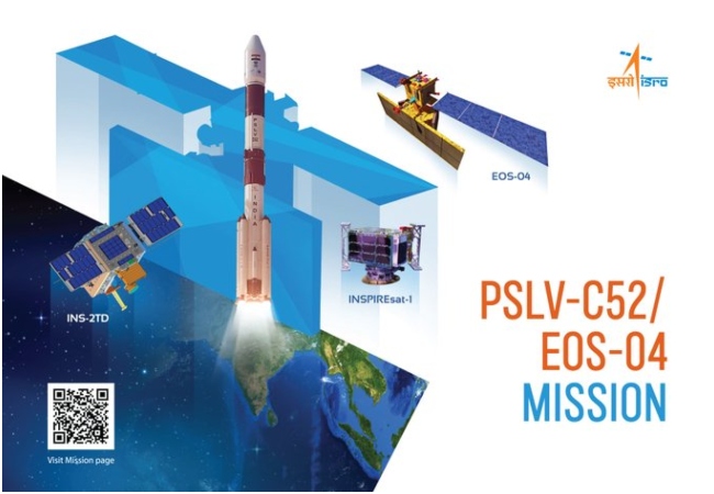
New Delhi: The Indian Space Research Organisation (ISRO) is set to start its year 2022 with the launch of the Polar Satellite Launch Vehicle, PSLV-C52. It is going to be the first space mission of S Somanath who took over the chairmanship of ISRO from Kailasavadivvo Sivan. Somanath replaced K Sivan on January 14, 2022. Taking to Twitter ISRO informed everyone that PSLV-C52 will leave the ground at 05:59 AM on February 14. The launch will be done from the first launch pad of Satish Dhawan Space Centre, Sriharikota. The launch of Polar Satellite Launch Vehicle, PSLV-C52 is scheduled at 05:59 hours on February 14, 2022 from the First Launch Pad of Satish Dhawan Space Centre, Sriharikota. Mission page: https://t.co/BisacQy5Of — ISRO (@isro) February 11, 2022 The countdown process to launch PSLV-52 has been started at 04:25 hours on February 13, 2022. One has to wait for the launch for 25 hours and 30 minutes from 04:25 hours. PSLV-C52/EOS-04 Mission: The countdown process of 25 hours and 30 minutes leading to the launch has commenced at 04:29 hours today. https://t.co/BisacQy5Of pic.twitter.com/sgGIiUnbvo — ISRO (@isro) February 13, 2022 This way you can watch ISRO PSLV-C52 satellite launch ISRO has also shared the details for those who are interested to know how to watch the live-streaming of the PSLV-C52/EOS-04. One can watch the live telecast of the launch through isro.gov.in, the Facebook account of ISRO, Twitter account, and its YouTube account. Live telecast of the launch begins at 05:30 hours IST on February 14, 2022. Witness the launch live through https://t.co/osrHMk7MZLhttps://t.co/SAdLCrrAQXhttps://t.co/0C5HanC1Io https://t.co/646iCVEsrY pic.twitter.com/RwogQyWWVu — ISRO (@isro) February 11, 2022 YouTube channel of ISRO: Why lunch of PSLV-C52/Eos-04 by ISRO is important ISRO said the PSLV-C52 is designed to orbit an earth observation satellite, dubbed as EOS-04. It will be carrying two small satellites namely INSPIREsat-1 and INS-2TD. It is reported that EOS-04 is a Radar Imaging Satellite that can provide high-quality images under all weather conditions. The images are considered to be very useful for sectors like Agriculture, Forestry, Plantations, Soil Moisture, Hydrology, and Flood mapping.